Huashan Spirit

The Huashan range is located east of Xi'an, where the famous Terracotta Warriors were found. This granite edifice has five separate peaks, each representing the five elements of the Taoist universe (earth, water, fire, wood and metal.) The enormity of this mountain will take your breath away. It takes tenacity and careful footing to hike this mountain, just as life requires of us. Endeavor to persevere!

The most treacherous mountain in all of China. This is the dangerous 'Dragon Ridge' with sheer drop offs on each side. Look closely to see people climbing this pathway.

The most treacherous mountain in all of China. This is the dangerous 'Dragon Ridge' with sheer drop offs on each side. Look closely to see people climbing this pathway.

Anita in 2012, hiking '10,000 steps straight up'! The title of our first book. Find it on Amazon!

Anita in 2012, hiking '10,000 steps straight up'! The title of our first book. You can download your own copy as a PDF file here!

Huashan Trek

Fellow Virtual Travelers and Historians,

Happy May Day! The month of May brings the hope of life blossoming and new beginnings! It is celebrated in the U.S. and in China it's a national holiday.

Our last email detailed the incredible cableway ride up to the West Peak of Huashan (including raw footage of some of the cable car ride):

http://www.sacredmountainodysseys.com/blog/2017/4/1/huashan-cableway

This month, we continue on that journey to see more details of our day on Hua Mountain in October 2016. According to the Garmin Trek, in 3 hours and 45 minutes, we hiked 2.3 miles on Hua's West and East Peaks. Our ascent was 986 feet with an overall descent of 1003 feet.

Here is an overview of the territory we covered on Huashan (zoom in and out to get a sense of this huge mountain):

Huashan Mountain region

Huashan's granite peaks, slopes and cliffs are as old as time itself. Its inaccessibility and treacherous nature served the purpose of the hermits who wished to pursue their lives with no interference from external forces.

Monks and martial arts practitioners living on Huashan over the centuries, developed training that is as unique and challenging as it is to be on the mountain itself. Powerful, fluid movements, high strikes, low strikes, and majestic poses that showcase the nature of this ancient enclave.

We discovered on our first research expedition in 2002, that the martial arts of Huashan had already been lost in China. Hua Mountain has become a religious sanctuary (and tourist trap) and the knowledge of ancient martial arts forms like the "Roads of Hua" have long been lost. We have not been able to find any martial arts schools on the mountain, or in the town of Huayin City (at the base of the mountain).

While our U.S. Kung Fu schools teach martial arts forms that were developed on Huashan, there is very little information about Huashan's martial arts online. This clip is the closest we could find although it is more of a gymnastic art, not a martial art and the moves do not match our forms:

In spite of the loss of martial arts knowledge, there are still colorful legends to document. For example stories surrounding:

     Lao Tzu's Pills of Immortality
     Dr. Hua Tuo - the great physician
     General Kwang Kung
     The Chess Pavilion

As you enjoy the included photography, imagine performing moves from the YouTube video mentioned above, in some of these locations!

Garmin Fenix watch GPS trek on Huashan.

HuaTrek - This is the raw GPS data we gathered on our GPS watch. Data points 1250 - 1921 represent the hike on the mountain. The orange route is our hiking trek.

Our Day on Huashan

The Garmin Huashan trek overlaid on GoogleEarth.

The Garmin Huashan trek overlaid on GoogleEarth. Mapping the GPS data to the online GoogleEarth service shows the diverse terrain we covered that day.

Windswept Huashan plateaus.

Windswept Huashan plateaus. Even the trees develop a toughness, in order to survive on this mountain. Life up there isn't easy, even if you're a tree.

The West Peak cornice with the plains and Huayin City in the distance.

The West Peak cornice with the plains and Huayin City in the distance. In 2002, after spending the night on the mountain to capture the sunrise, Dennis (and others on that expedition) walked to and sat atop the cornice on West Peak. The cornice is the middle peak in this photograph. Beyond that you can see the plains where Hauyin City spreads out.

Zoomed in on the precipitous West Peak cornice.

Zoomed in on the precipitous West Peak cornice. Zooming in on the cornice precipice, Dennis didn't realize until later, the potential danger he had been in, hanging out on rock that looks like it could break away at any time.

One of the hundreds (probably thousands) of bold and craggy outcroppings on Huashan.

One of the hundreds (probably thousands) of bold and craggy outcroppings on Huashan. Step after step for thousands of steps, a hiker will come across views of bold and craggy outcroppings. To be on this mountain truly makes one realize just how small we human beings really are.

A distant view of the Chess Pavilion on Huashan.

A distant view of the Chess Pavilion on Huashan. This location pays homage to a legend that is unique to Huashan. We've posted pictures of this pavilion before. Find the roof top along the edge of the closest mountain and follow the rim down and to the right. Atop the next plateau is the Chess Pavilion.

Reaching out with the camera lens to 'touch' the Chess Pavilion. It is still a long ways away!

Reaching out with the camera lens to 'touch' the Chess Pavilion. It is still a long ways away! In this photograph you see both the building above and the pavilion below. While we ourselves have not been out to the pavilion, we know people who have. The report is that the 'path' to this piece of legend is highly dangerous, at best. One's sense of balance had better be pretty good!

From lofty heights, looking down on Huayin City at the base of this famous mountain.

From lofty heights, looking down on Huayin City at the base of this famous mountain. From one of the plateaus, glimpses of the city below can be seen through the humid air.

Some of the raw, stark and wild beauty of this granite gem called Huashan!

Some of the raw, stark and wild beauty of this granite gem called Huashan! The raw and stark beauty of this mountain never ceases to amaze us.

Thanks for visiting Huashan with us - this is Dennis' favorite sacred mountain!


Blessings,
Dennis & Anita


Huashan Cableway

Fellow Virtual Travelers and Historians,

Happy April Fools' Day! Unlike many of the interactions you may have today, we are telling the straight truth!

After a recent rousing Kung Fu martial arts workout, an observation was made that if we'd hiked up Huashan more, instead of taking the cableway, we'd be in better shape! Ironically, for this month's update we'd already planned to talk more about the Huashan cableway and Garmin watch GPS trek!

On December 3, 2016, we shared an email titled 'China Travel Log 2016 - Garmin GPS Tracks', in which we introduced our use of a Garmin GPS watch to create treks of our adventures:

http://www.sacredmountainodysseys.com/blog/2016/12/3/china-travel-log-2016-garmin-gps-tracks

China's sacred mountain of Hua is about a 3.5 hour drive from Xi'an. Xi'an is where the Terra Cotta Warriors are located. Once a person arrives in the city (Huayin) at the base of Huashan, much is involved to get up on the mountain. Here are those laborious steps, which we accomplished using an electronic translator (as we had no local guide on this part of our 2016 trip):

     - taxi ride from the hotel to the Huashan tour bus station;
     - 45 minute bus ride to the cableway station parking lot;
     - 20 minute walk to the cableway station;
     - wait in line for 2 hours to get on the cableway;
     - 30 minute cableway ride across and up the mountain.

The price is the same whether you take the West Peak cableway, the Central Peak cableway or walk up from the base of the mountain. Walking from the bottom will take a day's hike just to get to Central Peak (if you take time to photograph along the way). You then would either opt to stay on the mountain overnight, or catch the last cable car back down the mountain.

So that we could see more territory on the mountain, we opted to use the new cableway that arrives at West Peak.

Here is a GoogleMap view of the cableway from to West Peak:

The GoogleMap view of the cableway station at the 'bottom' of the mountain:

To avoid the potential of dropping expensive cameras, Anita carried her iPod in her fanny pack and shot video of a small portion of the cableway ride (through VERY dirty windows that also had a lot of reflections). Here is a video of that raw footage:

When the weather is good, the sights on Huashan are breathtaking to say the least! The way is also treacherous and each step must be intentional, preceded by forethought.

Hua Cableway Data

Hua Cableway GPS Data - The amount of data collected on a basic GPS watch is astounding! From time/date stamps, to distance, speed, elevation and GPS latitude/longitude, it captured it all! In this screen shot of the Garmin Basecamp software, the data collected on the cable car ride up to West Peak has been highlighted. This shows the cable car ride had an average speed of 6 MPH, covering 2.5 miles, with an average grade of 21.9%. The orange colored track represents the cable car data selected in the overlaying spreadsheet.

Hua Cableway GoogleMap

Hua Cableway on GoogleMap - Imagine a line halfway down this screenshot from the top. This is the approximate path of the cableway, stretching from left of 'Chijian' on the left hand side, to West Peak on the right side.

Hua Cableway Station

Hua Cableway Station - The cableway station at the 'bottom' of the mountain, is the large brown roof complex near the center of this screenshot. The 2 hour waiting line happened in the buildings on the left side of the large courtyard area.

Rural Hua

Rural Hua - Blistering hot and humid in the summertime and freezing cold in the winter months, it is hard to imagine living in the 'foothills' of Huashan! Even though this is a famous and ancient mountain with centuries of rich history, current life in rural China is rough by any standard. Maybe there is running water, maybe not. Maybe there is indoor plumbing, maybe not. Maybe there is electricity, maybe not. You get the idea.

Fairy Mountain

Fairy Mountain - Many of China's sacred mountains are called 'Fairy Mountains' and in this photograph, you can almost see little winged fairies flitting from point to point! The mists and breezes come and go, revealing majestic and breathtaking scenes beneath them!

Hua West Gate

Hua West Gate - Gateways in Chinese architecture have a long and complicated history. Over time, the 'paifang' or gateway architecture and ornamentation indicated the importance of the place beyond the gateway (e.g. Imperial Palaces vs. rural villages). More information about gateway architecture can be found here: https://en.wikipedia.org/wiki/Paifang

Hua Cable Car

Hua Cable Car - Modern day cable cars are huge compared to the cable cars we've used in the past. Our 2002 expedition commonly offered cable cars that could hold only one American and their 20-pound backpack. Today's cable cars can hold 6 - 8 people per car!

Hermitages

Hua Hermitages - If you know what to look for, throughout Huashan small hermitages can be spotted high up on cliff walls. These were abodes hand hewn out of rock by monks seeking solitude in their paths of enlightenment. In this photograph, beside the leftmost people-sized cave, you can see hand hewn hand and toe holds for climbing up to the ledge above!

End of the Line

End of the Line - Arrival at the West Peak cableway station, found us INSIDE the mountain, entering a hermitage-like cutout that contained a tunnel leading to the nearest outside walkway.

So wherever you find yourself in life, just live in the moment and take one step at a time. That is the only way to conquer any mountain! Even when cable cars are available!

Blessings,
Dennis & Anita

Five Dragon River and Palace

Fellow Virtual Travelers and Historians,


High in the Colorado Rocky Mountains, the sun is shining and the wind is brisk. March is here already. Winter is still upon us as we reminisce about our past journeys on some of China's sacred martial arts mountains.

In this update we return to Anita's favorite mountain and temple - Five Dragon Palace on Wudangshan! From our first trip to China with our martial arts school (1996) to our most recent visit to China (2016), we've been to Wudangshan 6 times now. Of the sacred mountains we're researching, this mountain has the oldest history. Wudangshan myths, legends and folklore is the book we are currently writing.

You may remember that our trip in 2016 was encumbered by lots of rain. For the first time, we utilized a GPS watch to create downloadable treks as we wandered about China. Our previous trip (2014) is when we made the long hike to Five Dragon Palace in the Wudang mountain range.

After mapping our 2016 Wudang Trek up to the 'Parking Lot' (where our hotel was) on Google Earth, we did more map exploration and found the Five Dragon Palace:

When you zoom out (the minus sign) on the above map (depending on your screen size, it may be 5-6 zoom outs), look for:

Taichangguan 泰常观 , which is below and to the right of Five Dragon Palace (or Wulongcun.)

Taichangguan is near the Parking Lot where our hotels were located in both 2014 and 2016!

No wonder we were tired after that 7-hour trek down the Five Dragon River valley (with the last hour spent hiking UP the mountain)! With the devastating rains this area suffered between our last two trips, it's unlikely that the valley to Five Dragon Palace is even passable now.

We sent emails about this adventure during our 2014 trip to China (April 28th). This ancient temple complex is the second oldest temple at Wudang (the oldest temple complex is beneath the water of one of the reservoirs in the area).

To see that post and photos visit this link:

http://www.sacredmountainodysseys.com/blog/?offset=1398905820000

With support of the Tang Dynasty (627-649), the Five Dragon Palace Ancestral Hall was built. The Ming Dynasty also greatly respected the Wudang area and they are believed to have built around 215 additional buildings on the site, containing upwards of 850 rooms.

Tragically, a fire in 1930 burned the palace and buildings to the ground. The location (high on a mountain top in a very remote area) would have made fighting such a fire impossible.

It is mind-boggling how people could build such extensive structures in the middle of absolutely nowhere, that long ago. No heavy construction equipment, no automation, no gas-powered engines, no electricity, no modern tools as we know them. Wow!

Because of the remote location, Wudangshan temples and martial arts survived better than other temples, even when martial arts or Taoism were not popular with government officials. Wudangshan is the birthplace of Tai Chi.

Five Dragon Palace is definitely a place to return to someday!

Thank you for your interest in our travels - you make our efforts worth it!

Blessings,
Dennis & Anita

Mapping the trek from Wudangtown to our hotel on the mountain, helped us locate Five Dragon Palace.

WudangTrek - The yellow line is our bus trip GPS trek up the mountain from town, arriving at the 'Parking Lot' where our hotel was located. In the center of this picture is a graphic with these characters: 五龙村  This is Wulongcun or Five Dragon Palace! Mapping the trek from Wudangtown to our hotel on the mountain, helped us locate Five Dragon Palace.

Bird's eye view of the Five Dragon Palace.

Bird's eye view of the Five Dragon Palace. Our entry to the temple grounds was the path on the right hand side. We walked past the drum and bell towers and into the courtyard of antiquity itself. This day's story is chronicled in our '10,000 Steps Straight Up' book, starting on page 19.

A hidden gem along Five Dragon River.

FiveDragonReservoir - A hidden gem on the Five Dragon River! The path down included walking around this body of water and crossing to the other side of the river via the top of the dam. See if you can find it on the GoogleMap! (Hint: it is below the 'Parking Lot'.)

Quaint bridge allowing passage over a small waterfall, flowing into the Five Dragon River.

FiveDragonBridgeWaterfall - The path crisscrossed the river a number of times. This was a quaint area where a smaller stream joined the larger flow of water into the Five Dragon River.

Dwarfed by the enormity of the Five Dragon River.

Five Dragon River Crossing: Dennis was dwarfed on the man-made concrete stepping blocks across Five Dragon River. The subsequent rains and flooding likely destroyed this area.

Finding serenity in the raw and wild nature.

Finding serenity in the raw and wild nature: The hike along (and across) this river was breathtaking at every turn! With the dense foliage, you can see that walking across the Wudang mountain range would be slow and painstaking. Even if you had a machete.

Five Dragon Palace entry gate with its drum and bell towers.

Five Dragon Palace entry gate with its drum and bell towers: This is the view from the Five Dragon Palace courtyard, looking back towards the bell and drum towers. The brown building in the middle is where the monk tending the entrance, offered us water upon our arrival.

The glimpse back at the main temple as we descended down the back side of the mountain.

The glimpse back at the main temple as we descended down the back side of the mountain: After securing a car from town, we departed the temple grounds to hike down toward the not-open-to-the-public road. A glance backwards filled our hearts with awe. If only these trees and buildings could talk, the tales that they could tell!

Negotiating a ride to town after a very long day.

Negotiating a ride to town after a very long day: With waning daylight at 5 pm and Anita's right knee that had swollen to twice its normal size, Dennis was tenacious in finding a ride into town.

Wohing Museum - Chinese New Year Celebration

What an honor it was to return to the Wohing Museum in Lahaina, Maui to help them celebrate the 2017 Chinese New Year! The year of the Fire Rooster!

Check out professional photographs taken of the day-long event:

http://melanieagrabante.zenfolio.com/p165389697#h82e03218

It was delightful to meet two classes of local students and run them through some martial arts paces, from Tai Chi's 'hanging by a thread' to General Yueh Fei's 18 continuous postures! Thank you Dr. Busaba Yip for sharing your photograph!

Dennis and Anita with a local class of 5th graders.

Dennis and Anita with a local class of 5th graders.

Happy Chinese New Year and Temple Archeology

Fellow Virtual Travelers and Historians,

Happy Chinese New Year! Today marks the beginning of 2017 - the year of the Fire Rooster:

http://www.thechinesezodiac.org/


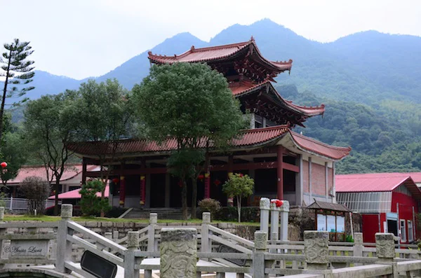
Toward the end of last year's trip (October - November 2016), we mysteriously disappeared to research another sacred martial arts mountain. This time we ended up in Fujian Province along the eastern coast of China. Our discovery, it turns out, is quite significant to the Shaolin Kung Fu martial arts. It seems that we are some of the first caucasians to visit the site.

After leaving Beijing we arrived in Fuzhou for a two-night stay with meetings and touring in the city. Then we boarded a small bus for the trip through the city of Fuqing and into the wilds of rural China. The ride was bumpy at best, along pot-holed and rutted roads through small old-style towns and past rural farms that were spread out along the way. Rain had crowded in on us as we headed out but as we got closer to the temple site, the clouds lifted and the rains stopped. Our excitement was not in the least bit hampered, even by the dirt-laden windows of the bus!

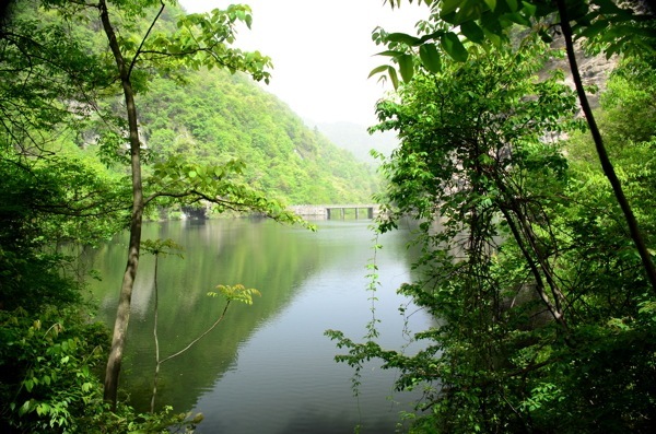
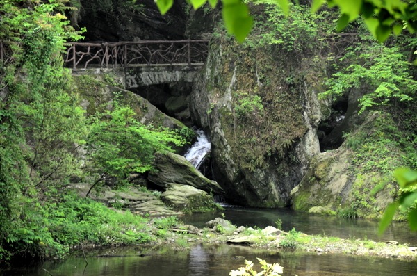
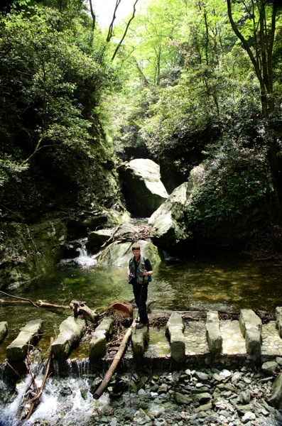
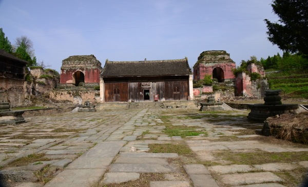
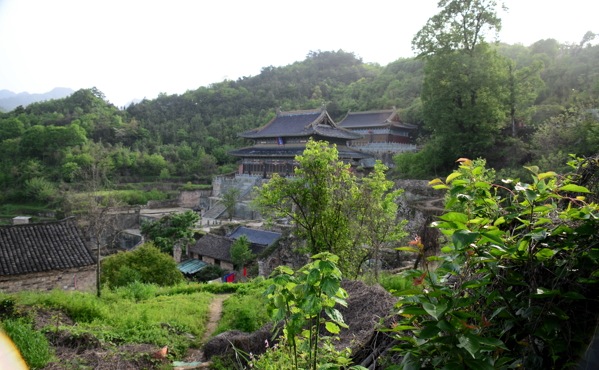
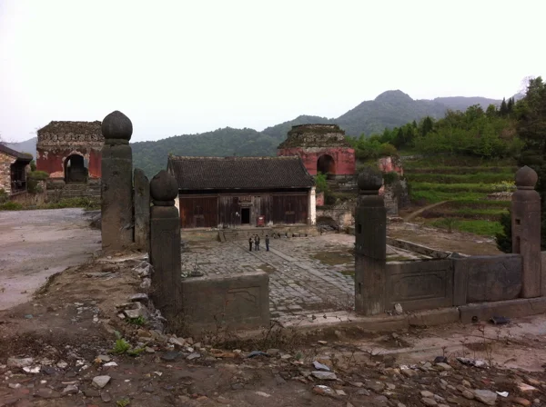
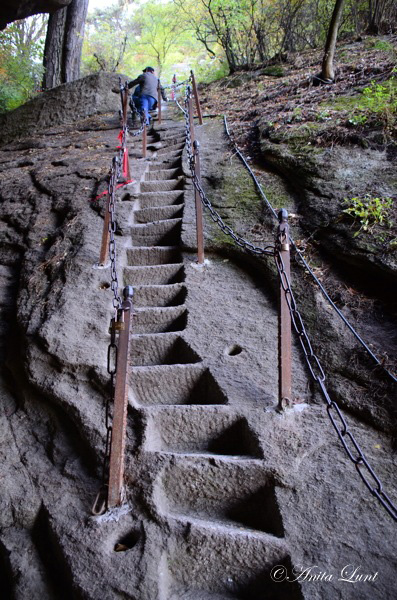
Exiting the bus, the three musketeers were encouraged to wander the temple grounds unhampered, for about 2 hours. From the grand entrance gate, through the complex and finally coming upon ancient ruins in the back that we could wander through on foot, our eyes and minds could hardly comprehend the great honor bestowed upon us.

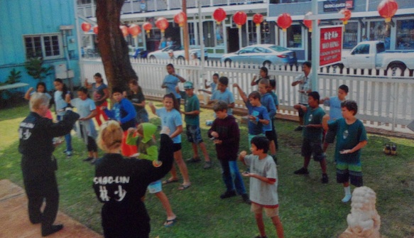
Meeting in person, the Head Abbot and the Monk in charge of martial arts were icing on the cake! Both of these gentlemen where young boys at the Northern Shaolin Temple when we visited China with our Kung Fu school in 1996. Seeing our sea of purple tour shirts and watching our group perform, changed their perspectives on life.

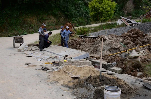
While the ruins were originally discovered in 1996 and much of the temple grounds have been rebuilt, the location is largely unknown, even within China. At one point, it is believed that this site housed, fed and taught up to 1,500 monks at one time.

We were challenged during our visit, to build an English presence for this Shaolin temple site online, since very little information is available anywhere. So, we are pleased to present to you, our contribution to the Southern Shaolin Temple of Fuqing:

https://www.southernshaolintemple.org/

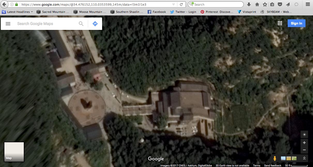
Here is a bird's eye view of the temple site, complements of Google. Zoom out and pan around as you wish:

To pan around, click and hold the mouse on the map, then move the mouse.

There will be much to learn about this temple's history and we'll need more photographs than what we could muster in our 2 hour visit. Watch for updates, as we glean more history and post more photographs! We'll be adding a 'Links' page as we uncover more information about this area. Updates on our SacredMountainOdysseys.com website will also be made, adding the Fuqing temple location as a sacred martial arts mountain.

Blessings,
Dennis & Anita

Happy New Year - the year of the fire rooster!

Happy New Year - the year of the fire rooster!

West Lake in Fuzhou, China.

West Lake in Fuzhou, China. The lake at night outside our hotel.

Fuqing Southern Shaolin Temple Trek.

Fuqing Southern Shaolin Temple Trek: Tracing the route from the city of Fuzhou, through Fuqing, into rural China, through the town of Shaolincun and finally arriving at the Southern Shaolin Temple.

Life in rural China.

Life in rural China: The side of life in China that not many tourists get to see (pardon the dirty windows of the bus!).

One of many buildings on the Southern Shaolin Temple grounds, outside of Fuqing, China.

One of many buildings on the Southern Shaolin Temple grounds, outside of Fuqing, China: Once past the main entrances, the grounds open up showcasing many buildings, ponds (with turtles and koi fish), walkways, grass, flowers and trees.

Continuing construction at the Fuqing temple area.

Continuing construction at the Fuqing temple area: Workers hard at it, using manual tools in their labor.

Original Southern Shaolin Temple ruins.

Original Southern Shaolin Temple ruins: Crumbling walls, staircases, covered sewage troughs and strewn rock from ancient buildings. Words cannot express the feeling of walking in ancient times.

China Travel Log 2016 - Garmin GPS Tracks

Fellow Virtual Travelers and Historians,

On our recent trip to China, we had some old reliable equipment with us, as well as some new gadgets. Dennis outfitted himself with a GPS unit that talked to an App on his iPod. This allowed us to 'see' where we were on the iPod map and was especially useful in cities. Anita got herself an older model of the Garmin Fenix GPS watch, to attempt to record some of our treks. It worked and we have data on a total of 29 different tracks. We were gone for 26 days, so we gave the watch a good workout!

To introduce you to the Garmin Fenix, let's talk about Huashan. That's the huge granite mountain that contains the plank walk (which we were still not able to complete, due to high winds this time):

http://www.wherecoolthingshappen.com/huashan-crazy-plank-walk/

We sent you an update from Huashan on 10/21/16. That day we recorded our West and South Peak treks with the new Garmin Fenix GPS watch. From the taxi ride from the hotel to the Huashan shuttle, to the cable car, to the hiking on the mountain, and then back to the hotel, attached is a screenshot of our trek that day (HuashanGPSTrack).

Glancing at the data, it looks like we hiked over 2 miles on the mountain that day, covering an area of over 26,000 square feet. We'll do more in-depth research to find out if that's 2 miles on the flat, or taking into account that most of the hike was up and down (paths and steps). Eventually we'll build adventures on Garmin Connect and map our treks to GoogleMaps.

For now, here's a bird's eye view of the entirety of Hua Mountain:

Here's a zoom in to the area we hiked:

Garmin Fenix Track - Huashan

GPS Route: The trek from our hotel, up the mountain, hiking on Huashan, down the mountain and back to the hotel.

Dennis, Anita and Karl on the South Peak of Huashan.

Dennis, Anita and Karl on the South Peak of Huashan. The Three Musketeers at the South Peak of Huashan. Yes, it was VERY windy!

Zoomed in view of the Chess Pavilion at Huashan

Telephoto in view of the Chess Pavilion at Huashan.

One of the nearly vertical hand hewn stairways.

Some of the nearly vertical hand-hewn steps that dot the mountain sides.

2017 calendar back cover.

A glimpse of each month's photos - our 2017 calendar back cover.

The busiest time of the year is upon us, so you'll next hear from us in the New Year!

Blessings,
Dennis&Anita